|
|
 |
|
|
 |
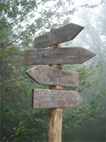
| Route
2 |
|
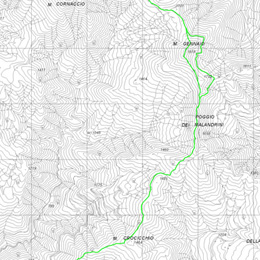
| 2- ALTERNATIVE
ROUTE Towards Monte Gennaio |
| |
| Slope |
833 meters |
Equipment |
water bottle, camera,
trekking shoes |
| Length of |
21 km |
Duration of route
|
6 hours |
| Difficulty |
Average |
Type of path |
Rough track and footpath |
| Recommended period |
spring, summer, autumn |
Starting point |
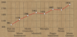
Pian dei Termini (981
meters above sea level) |
|
|
|
| |
   |
From the astronomy observatory car park
you take the footpath (see the previous itinerary) till you reach
the freestanding beech wood. After the bend you continue for about
20 meters and turn left into the footpath CAI no. 2 which climbs steeply
and crosses the fir wood, on the meridian side of Monte Terminaccio
(1154m) and from here, following the ridge, you move onto Mount Crocicchio
(1366m), the destination of the traditional religious procession of
the ascension. From this point in the Teso Forest you can see both
part of the crest of the Apennine Mountain Gennaio (also called "Uccelliera",
1814m) and as far as the mountain Libro Aperto (1937m), and make out
the characteristic peak of Mount Cimone (2165m).
Climbing again for a small stretch of the ridge and crossing footpath
CAI no. 00 in the Monticelli zone (1463m), which drops down to the
right to the pass "Passo dell'Oppio" (821m), following the
mountain line, you reach Maceglia (1424m). At the crossroads keep
going on the path CAI no. 00, which crosses a beech wood and leads
to an open area. You keep climbing until you get to the "Poggio
dei Malandrini" (1662m, just above the Montanaro refuge) where
you come across the G.E.A. (Grande Escursione Appenninica - Great
Apennine Excursion), which you follow for a small stretch. At the
pass "Passo della Nevaia" (1617m) you find a fork in the
road, you turn left along the path of the ridge which climbs to the
peak of Mount Gennaio (1814m). The return leg can be taken going down
the pass "Passo del Cancellino" (1634m) to link up with
the footpath which follows the mountainside of Mount Gennaio till
the "fonte dell'Uccelliera" (1675m), and those who want
a slight variation can, in a few minutes, get to the refuge at Porta
Franca. Thereafter you climb to the pass "Passo della Nevaia"
taking again the CAI footpath which takes you back to the "Pian
dei Termini".
|
| |
|
 |
| ALTERNATIVE
ROUTE Towards Monte Gennaio |
| The
route follows well-marked CAI paths that cross the Teso Forest.
From Pian dei Termini the route is mostly uphill except a few
stretches, until you reach the midway point. Along the path
there are great viewpoints looking out onto the Northern Apennines.
|
| Click on the map to open a bigger
image, if you prefer you can download the GPS file in
the
download page. |
|
| |
How to reach Gavinana by
car:
- from Pistoia: Take road SR no. 66 until Campotizzoro,
take a right on the provincial road near "Ponte alla
Falce". This road leads to Gavinana after about 5 kilometers.
- from Lucca Take road SS no. 12 "dell'Abetone e del
Brennero", take a right on road SR no. 66 near La Lima
towards San Marcello Pistoiese.
|
|
| |
|
|
 |