   |
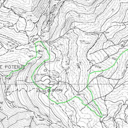
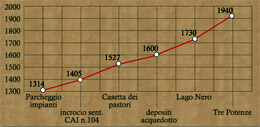
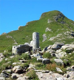
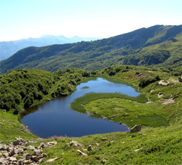
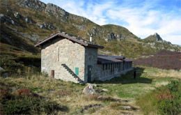
From the carpark, near the ski lifts (1309m) in the Valle del Sestaione, you start to climb slowly along a rough track. Having crossed the bridge over the river Sestaione, you keep climbing following the white-red signs of path CAI no. 104 (CAI is the Italian Mountaineering Club). After about one kilometer, near a tight bend (1405m), you join up with the mule track that runs parallel to the river. At the end of this, after a ford and a sharp climb, you get to the Casetta dei Pastori or Shepherd Hut (1527m). From the small refuge the path climbs quickly to a drinking water reservoir (1490m) and then links up with path no. 102, which comes from Boscolungo (GEA-MPT). You continue on the left for several hundred metres crossing a wood of red firs, then head right following a ditch surrounded by raspberry bushes climbing steeply (15 mins) to reach the large plain of the glacial hollow of the “Black Lake” (Lago Nero); high on the right it is possible to see a Swiss Mountain Pine (Pinus mugo) wood. From here you turn right, and in a few minutes, you arrive at the lake itself (1730m). From the lake, the path continues to climb cutting through the southern side of the Alps of the “Tre Potenze” (Three Powers) and reaching the Passo della Vecchia. Turning left again you take the footpath CAI no. 00 that climbs very steeply to the top of the “Tre Potenze” (1940m).
Coming back you can take the path CAI-MPT no. 100 from the “BlackLake” to the Foce di Capolino. From the refuge you head down to the right following a stretch of footpath, which, linking up with the old “Blue” ski slope, crosses the right side of the Sestaione valley running alongside the border with Nature, reserve “Riserva Naturale Orientata di Capolino”. You finally get back to the starting point (and the nearby Botanic Gardens).
.
|