    |
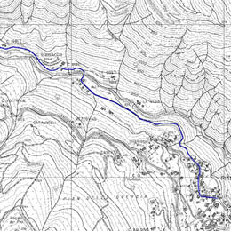
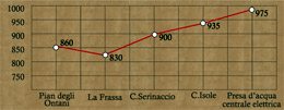
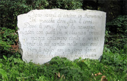
When reach the place called “La Peschiera” (which has a car park) you follow “viale Beatrice” which cuts through the area of “Pian degli Ontani” (alt. 860m). Go past the fork on the right for Pian di Novello and head down for 15 minutes to the “Frassa” (alt. 830m), a small village at the dam of the Italian energy company. Along this short stretch you will see on the left the “Buca delle Fate”, a small formation in the sandstone rock, from which a fixed temperature current of air comes out. Along the route it is also possible to read some of the verses written by the “shepherd poetess”, Beatrice from the Pian degli Ontani, engraved in blocks of sandstone.
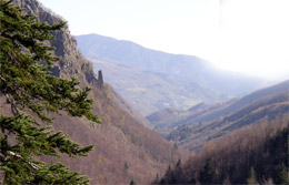
Having then crossed the Sestaione rapids on a narrow walkway you find yourself on a mule track,which, with a steady climb, brings you to the “Case Mori”, where it is possible to see a traditional chestnut drying hut and, on the left, a ruin of an old mill and thereafter (20 minutes) leads to Serinaccio (alt. 930m). From here a rather well hidden, steep footpath takes you north, on impervious land, to the “Torre del Fattucchio”. Our route – somewhat simpler – carries on along the rough track road, which, with some ups and downs, follows the line of the river Sestaione. Along the way you can see the outline of the Torre del Fattucchio that dominates the valley. This rough track takes you to the source of the water for the electric company, the halfway point of our route. Near this water source there is a footpath, which breaks off from the rough track and zigzags rapidly upwards to the tower in about half an hour’s walk. During this stretch it is not uncommon to see roe deer.
.
|