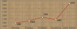
    |
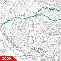
From the summit of Mount maiori we drop firstly to the mouth of
the river Verginina of Serrabassa and then take a dirt track to
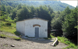
link up with the "Casetta di Lapo" (1503 metres). Here,
a small shelter is open during the summer.
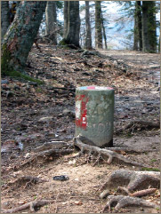
From the "Casetta di Lapo", path CAI no. 00 rises quite
steeply to the top of "Mount Libro Aperto", reachable
in less than two hours. Along the route you can find the stone cylindrical
markers of the border between the lands of the Grand Duke of Tuscany
and the Duke of Modena. After overcoming some sandstone layers you
reach "Selletta of the Mount Libro Aperto" (1860m). From
here you climb again to the peak of "Mount Rotondo" (1937m),
one of the two peaks (the other is that of Mount Belvedere, 1896m),
which give the characteristic shape of "Mount Libro Aperto"
(Open Book). From this position it is possible to admire suggestive
panoramas of the side of the Apennines and, when the weather is
clear, remarkably even part of the alpine ridge.
On the Modena side of "Mount Libro Aperto", during summer,
it is possible to see the flowering rhododendrons. Originally from
the Alps, this plant arrived to the area about 200,000 years ago
during the last glaciations. Our journey continues downwards to
the "Selletta of Mount Libro Aperto", then right on a
dirt track through the glade, past a spring on the right, then into
the "Vallon dei Faggi" along a mule track. This track
leads through beech trees and bilberry bushes, back to the "Cassetta
di Lapo". Proceeding towards "Mount Maiori", it is
advisable to take path no. 5 to the right, which leads back to the
fountain.
|