|
|
 |
|
|
 |
| Route
3 |
|
| 3
- Bicycle circuit of Orsigna |
| |
| Slope |
1050 m
|
Recommended period |
summer |
| Length of return trip |
33 km |
Starting point |
Orsigna (806 metres
above sea-level) |
| Difficulty |
medium * |
Type of path |
Asphalt road, dirt
track, footpath |
|
|
| (*) The route almost always follows a dirt track, which is relatively
easy but requires some training due to the steep climb. |
|
| |
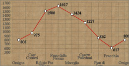   |
Leaving the Square of Orsigna, follow
the road for about 2 km until the forking near the village of Case
Corrieri (975 m). Take the dirt track, which climbs into the woods.
It will be possible to replenish water supplies at a small fountain
located in Il Salatoio after the barrier of Comunità Montana.
The dirt track twists with a series of sharp bends for about 6.5 km
going through a beech wood. The road then meets a forking (with path
CAI no. 35A to the shelter of Portafranca), near a hairpin bend which
offers a great view over the valley, which takes to the "Fonte
dello Spirito" (spring of the spirit). It is advisable to keep
on the dirt track, which continues to climb steadily for 2 km. A short
flatter stretch cuts across the side, slowly going down to Pian Grande,
a glade used for pasture, near a shelter belonging to the Comunità
Toscana. Take path CAI no. 35 and proceed partly on foot as it climbs
steeply up to the shelter of Porta Franca (1580 m) in about 10 minutes.
From the shelter continue on the same path, which leads to the mountain
pass of Nevaia (1617 m) on the Apennine ridge (path CAI no. 00) and
go down to the fountain of Cacciatore, then to Maceglia (1424 m).
Turning left go down first on the footpath then on the dirt track
to Casetta Pulledrari. Continue on the asphalt road (for about 1.5
km) and at the hairpin bend turn left on a dirt track. This track
- known to the locals as "strada di Spinarazza" - cuts across
the southern side of Mount Grosso, keeping a steady 110 m altitude.
After a few kilometers take the trekking path MPT coming from Pontepetri
and which leads to the farm of Pian di Serra (862 m). Leaving the
farm, continue down the dirt track, then join road no. 632 "Traversa
di Pracchia" which connects road SS n. 66 to the road Porrettana.
Once on the asphalt road proceed left towards Pracchia (617 m) and
you will reach Orsigna after 4 km.
|
| |
|
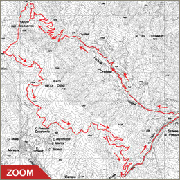 |
| Bicycle circuit
of Orsigna |
This
33-km circuit is fairly difficult due to its steepness, and
to be covered almost entirely by mountain bike. From the village
of Orsigna, go to Case Corrieri and take the dirt track, which
climbs to the shelter of Porta Franca (the last stretch to be
covered on foot). From the shelter, go up steeply on the Apennine
ridge and then slopes down a track to Casetta Pulledrari. After
a few km on asphalt road, take an easy dirt track, which cuts
across the Southern side of Punta della Crina and goes down
to the asphalt road for Pracchia and then reaches Orsigna.
It is highly advisable to wear a helmet and bring a water bottle
|
| Click on the map to open a bigger
image, if you prefer you can download the GPS file in
the
download page. |
|
| |
Come si raggiunge in auto
Orsigna:
- da Pistoia: raggiungibile tramite SS n. 66 fino
a Pontepetri e poi SS n. 632 "traversa di Pracchia"
per 4 km con deviazione a sinistra dopo aver superato l'abitato
di Pracchia.
- da Lucca: raggiungibile tramite SS n. 12 "dell'Abetone
e del Brennero" deviazione a destra presso La Lima
sulla SS n. 66 fino a Pontepetri e poi SS n. 632 "traversa
di Pracchia" per 4 km con deviazione a sinistra dopo
aver superato l'abitato di Pracchia.
|
|
| |
|
|
 |