|
|
 |
|
|
 |
| Route
2 |
|
| 2-
The muletrack to Popiglio and towers of Popiglio |
| |
| Slope |
580 metres |
Equipment |
Camera, trekking boots |
| Length of return trip |
5 km |
Duration of route
|
3,5 hrs |
| Difficulty |
Medium |
Type of path |
Foot-path, mule track,
dirt road and asphalt road |
| Recommended period |
All year |
Starting point |
Bridge of Castruccio |
|
|
| Signs: white and red MTP |
|
| |
 |
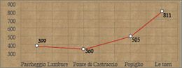
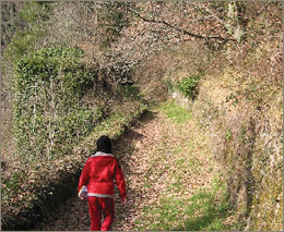
Having crossed the bridge of Castruccio
(360 metres above sea-level) the walk continues on the paved mule
track that rises steeply skimming the ditch of Vingone. The water
of this ditch used to supply the mills, only ruins today, where wheat
and chestnut were ground. The mule track, which is still in good condition,
rises with some sharp bends through a thick wood of locust-trees and
rare varieties of pine and chestnut trees. It then reaches the town
of Popiglio; the origin of this name appears to be from a roman commander
(Marco Popiglio Lenate or Lucio Caio Pompilio) who had set up their
campsite in this area.
Having gone through a stone archway, the procedes in Via della Veduta
(View Road). This ancient road is the connection to the Lima Valley.
A network of small paved roads looks onto the Lima Valley through
arch and terraces. Some Verginine dating back to 18th century lead
what used to be the processional walk of the town.
After crossing through the medieval town we reach the parish of Saint
Mary, which was built in late-Romanesque style seems to date back
to 1271. Consisting of a single nave, its façade has a door
surmounted by a suspended prothyrum and three mullioned windows can
be seen above, one with three lights flanked by two with two lights.
There are various works of art preserved inside, which include an
antique stone pulpit.
From the parking lot (505 metres above sea-level, near the tennis
courts, we take via Fabbrica, which goes around the public gardens
with the monument to soldiers fallen during the Great War. It then
goes up past the gardens up to Via Valley (Valley Road), following
an old processional path. We continue to walk uphill, past a group
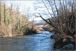
of houses, to a panoramic terrace. Looking East we can see the entire
valley if the Limestre river until its confluence into the Lima Valley.
We take a right into Via Ritondolo and go along this road until we
reach a dirt path. Just before the "Rupine" cottage, we
take the MPT path forking off to the left, sloping rapidly uphill
in the woods until the main road. After a few hundred metres, we turn
left on a path, which goes uphill to the ruins of the medieval towers,
811 metres above sea level. We then return downhill on the same path,
down Via Ritondolo, and proceed on Via Eusebio until a sharp bend
to the left. There we take a right on to Via della Croce (Road of
the Cross), a narrow paved road, which descends rapidly in the western
side of the town. A short while ahead we leave Via di Canapali, an
old road connecting the town and the church of Saint John (now a private
villa). Once near the main road we take a left onto Via delle Marche,
which goes through a small town and finally reach the convent of Saint
Francis and Saint Dominic.
Going along Via Arco Lungo (Long Arch Road) we reach once more the
main road near the parish of Saint Mary and then the parking lot.
We then continue downhill along the mule track to the bridge of Castruccio.
|
| |
|
 |
| The muletrack
to Popiglio and towers of Popiglio |
| Hacing
crosse the bridge of Castruccio we take the old mule track,
which goes up to the town of Popiglio. Walking through old picturesque
streets we reach the historical part of town and on to the ancient
towers built on the ridge dominating the valleys of Limestre
and Lima. |
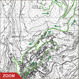
| Click on the map to open a bigger
image, if you prefer you can download the GPS file in
the
download page. |
|
| |
Directions:
- From route SS n. 66 Pistoia - La Lima take the main road
"mammianese-marlianese" SS n. 633 at "La
Colonna" towards Piteglio.
- After about 2,5 km, near a hairpin bend at "Il Curvone"
take the road towards "Lolle". After 300 metres
keep to the right and follow the road for about 3 km.
|
|
| |
|
|
 |