|
|
 |
|
|
 |
| Route
3 |
|
| 3
- POPIGLIO CYCLE PATH - MTB PATH |
| |
| Slope |
850 metres |
Advised
period |
All year |
| Distance of return
trip |
37 Km |
Starting point |
Bridge of Castruccio
(360 metres above sea-level) |
| Difficulty |
Medium |
Type of path |
Foot-path, mule track
and asphalt road |
|
|
|
| |
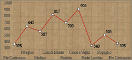   |
Leaving the field allocated for parking near Lambure, we go up
to the hairpin bend and go back to road 633 "mammianese-marlianese"
towards Piteglio. A few hundred metres past the village of Migliorini
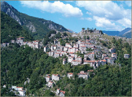
we turn right. When we get to the town of Piteglio we go past the
school and continue to the bottom of the valley and continue for
6 km until Casa di Monte walking along a quiet shaded road. From
Casa di Monte we go a little way uphill and then downhill to join
the road towards Pescia. We reach Crespole and after 1km Lanciole.
Following a hairpin bend we go up towards Pontito and turn right
just before the town on a road that goes over the town.
We go past the church of Madonna delle Grazie and the road becomes
unmade just before the aqueduct. We continue on the dirt track leading
to us to the village Craco a Veglia (906 metres above sea-level)
and its characteristic chapel.
We procede to the left along a "red" road that skims the
ridge, offering a fantastic view over "Svizzera Pesciatina"
(literally Pescia Switzerland), and we continue until the forking
which takes towards Lucchio. The dirt track winds around the eastern
slope of the Penna di Lucchio, an impressive calcareous rock formation,
which rises behind the medieval castle of Lucchio. We continue downhill
on the asphalt road until the bridge over the stream Lima near the
Tana a Termini. We take road 12 East and walk up for about 4 km
to Popiglio, where we then take the mule track at the bridge of
Castruccio (see Itinerary 2).
|
| |
|
 |
| Cycle path
of Popiglio |
| This
path is 37 km long and requires a certain amount of effort.
It is on asphalt roads to be covered entirely on mountain bikes.
From the parking lot at Lamure we reach the road going to Piteglio.
After a few hundred metres past the village of Migliorini, we
veer right towards Piteglio. At the schools we take a downhill
road to the valley and then back up to Casa di Monte. Here we
go down to the road to the villages of Crespole, Lanciole, then
Pontito and up to Croce a Veglia. On a dirt track we go down
to Lucchio and proceed on asphalt road to the bridge, near the
"Tana a Termini". Here we go back up to Popiglio and
then down to the bridge of Castruccio. It is highly advisable
to wear a helmet and bring a water bottle. |
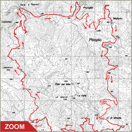
| Click on the map to open a bigger
image, if you prefer you can download the GPS file in
the
download page. |
|
| |
Directions:
- From route SS n. 66 Pistoia - La Lima take the main road
"mammianese-marlianese" SS n. 633 at "La
Colonna" towards Piteglio.
- After about 2,5 km, near a hairpin bend at "Il Curvone"
take the road towards "Lolle". After 300 metres
keep to the right and follow the road for about 3 km.
|
|
| |
|
|
 |